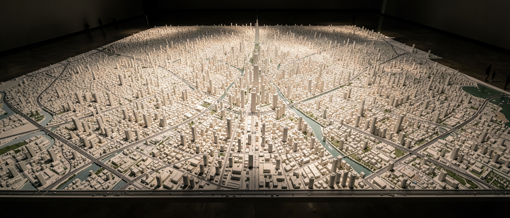
Walk onto the third floor of the Shanghai Urban Planning Museum, on People’s Square in the Huangpu District, and the floor stops looking like a floor. In its place is a city. Tiny skyscrapers rise in clusters no taller than a soda can. Thin ribbons of pale blue trace the course of the Huangpu River. Streets run off in every direction, narrow enough to follow with a fingertip, spreading across more than 1,000 square feet (over 100 square meters) of open room.
It’s reportedly the largest scale model of a city ever built. Before getting into how solid that claim actually is, it’s worth sitting with the stranger question first: why does a city this size even need a copy of itself?
Why Build a City Twice?
A drone can map a skyline in an afternoon. Architecture software can render a tower from every angle before a single brick is laid. So why would anyone spend the time, money, and labor to build an entire district by hand, tiny building by tiny building?
This wasn’t made for tourists with cameras. Shanghai’s planners built it as a working tool, something officials and engineers used to study the city before large parts of it existed at all. The interesting part isn’t that they built it. It’s what a physical model lets you do that a screen simply doesn’t.
A Forecast You Could Walk Around
The model shows central Shanghai as urban planners envisioned it would look by 2020. Every building taller than six stories within the city’s inner ring, an area of about 42 square miles (110 km²), was represented in miniature, long before most of it had broken ground.
That matters because a blueprint is flat and a screen is small. Crouch down next to one of the model’s tiny streets and you get something close to a pedestrian’s view of that block. Stand up and step back, and you can see how one district’s future towers would throw shadows across another, or how a new road would actually line up with the river. Politicians, investors, and residents who couldn’t read a technical drawing could still grasp scale, density, and sightlines just by walking the room.
Shanghai wasn’t modeling the city it already was. It was modeling the city it intended to become, a forecast built out of plastic, paint, and glue that you could circle on foot.
A City That Needed a Big Model
Shanghai’s extended metropolitan area holds more than 20 million people spread across nearly 2,046 square miles (5,300 km²), one of the largest and fastest-growing urban regions anywhere on the planet. Trying to plan a city at that scale with a model the size of a kitchen table would be a little like trying to read a novel through a keyhole: technically possible, practically useless.
The bigger the ambition, the bigger the model had to be. A city expanding by the millions needed a forecast you could actually walk into, not one you had to squint at.
What We Don’t Actually Know
“Reportedly the largest” is carrying some weight in that sentence, and it deserves to be said plainly: there’s no Guinness-style record confirming it, and no clearly documented source naming exactly who built it or when. The original description of the model, from a write-up circulating around 2008, put its area at just over 100 square meters (about 1,076 square feet). Other, more detailed accounts describe a version closer to 480 to 600 square meters (roughly 5,200 to 6,460 square feet), which may be the same exhibit after an expansion, or may reflect confusion with a different model in the same hall. Neither explanation is confirmed.
The scale ratio is similarly unsettled. Most sources put it at 1:500, meaning every half-inch on the model stands for roughly 20 real feet, but other accounts cite 1:200 or even 1:2,000, suggesting different sections of the hall may use different ratios. And since the model was built to predict 2020, nobody has published a clean accounting of how much of that imagined skyline actually matched the real one once the year arrived, and how much got redrawn along the way.
None of that makes the model less worth seeing. It just means the honest version of this fact has a few open edges, and noticing them is part of actually understanding it rather than just repeating it.